+86 13520127780
  info@jingelway.com








How UAV Ultrasonic Wind Sensors Enable Low-Altitude Wind Monitoring
Release time: 2026-09-02
Wind conditions can change significantly between ground level and the altitude where a drone is actually operating.
A conventional weather station may tell operators what the wind is doing at a fixed location, but it cannot always describe the airflow encountered by a UAV tens or hundreds of meters above the surface.
That difference matters in applications such as:
- Low-altitude meteorological research
- Industrial UAV inspection
- Environmental monitoring
- Emergency response
- Air pollution studies
- Agricultural monitoring
- Wind resource surveys
- Atmospheric boundary-layer research
This is where a UAV ultrasonic wind sensor becomes valuable.
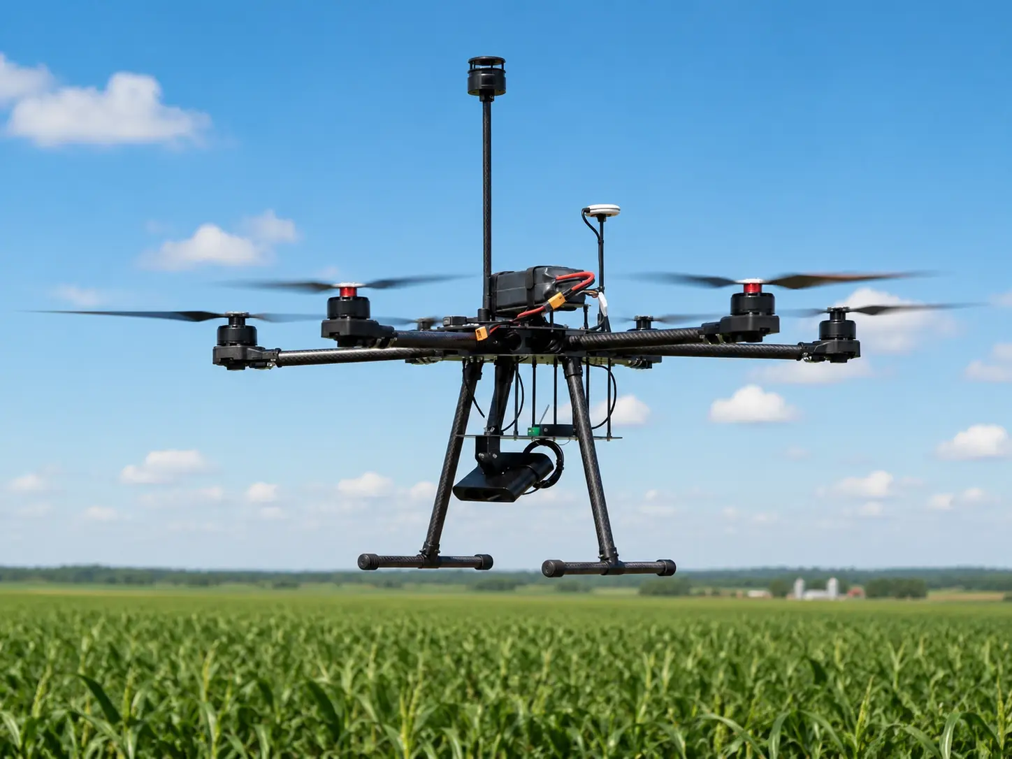
Mounted directly on an unmanned aerial vehicle, the sensor travels with the aircraft and measures wind speed and wind direction at different locations and altitudes.
Instead of producing a single fixed-point measurement, a UAV can therefore help build a more detailed picture of the local wind field.
Why Is Ground-Based Wind Data Not Always Enough?
Most conventional weather monitoring systems measure wind from a fixed mast.
That approach is ideal when the objective is long-term monitoring at a specific location.
But the atmosphere is three-dimensional.
Wind conditions may vary because of:
- Altitude
- Terrain
- Buildings
- Vegetation
- Temperature gradients
- Local convection
- Coastal effects
- Industrial structures
- Mountain valleys
- Urban canyons
For example, a weather station installed 10 meters above the ground may record a relatively low wind speed while a drone operating at 100 meters encounters stronger airflow.
Similarly, wind direction near a building can differ considerably from the airflow above the structure because of turbulence and wake effects.
A UAV-mounted sensor allows measurements to be taken closer to the actual point of interest.
This makes mobile wind sensing useful when the goal is to understand how wind changes with both altitude and position.
For projects requiring a lightweight sensing platform, see the UAV Ultrasonic Wind Speed Direction Sensor.
What Is a UAV Ultrasonic Wind Sensor?
A UAV ultrasonic wind sensor is a compact anemometer designed to measure wind speed and wind direction while installed on a drone or other unmanned platform.
Unlike conventional cup anemometers and wind vanes, ultrasonic sensors do not depend on rotating mechanical components.
Instead, they use ultrasonic signals transmitted between sensing elements.
The movement of air changes the travel time of the acoustic signal.
By comparing the propagation time of ultrasonic signals traveling in different directions, the sensor can calculate:
- Wind speed
- Wind direction
This measurement principle enables a very compact sensor structure.
For UAV applications, this is particularly important because every additional gram affects payload capacity, power consumption, flight endurance, and aircraft stability.
How Does Ultrasonic Wind Measurement Work?
Imagine two ultrasonic transducers facing each other.
When there is no wind, an ultrasonic pulse traveling from Point A to Point B takes approximately the same amount of time as a pulse traveling from Point B to Point A.
When wind begins to move along that path, the situation changes.
The ultrasonic signal traveling with the airflow reaches the opposite sensor slightly faster.
The signal traveling against the airflow takes slightly longer.
The sensor measures these very small time differences.
Using multiple ultrasonic paths positioned in different directions, the instrument calculates the wind vector.
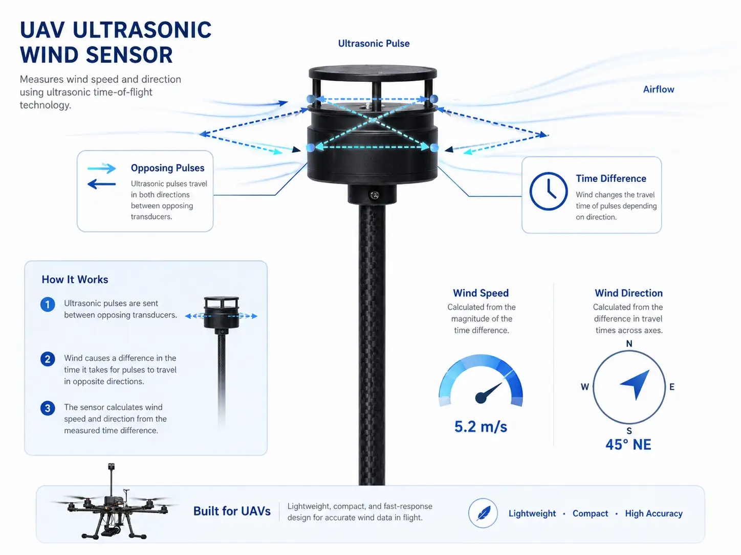
A simplified process looks like this:
Ultrasonic Pulse Transmission
↓
Measure Travel Time in Multiple Directions
↓
Calculate Time Difference
↓
Determine Airflow Vector
↓
Output Wind Speed and Wind Direction
This measurement method eliminates the need for cups, propellers, or mechanical wind vanes.
Why Ultrasonic Wind Sensors Are Suitable for UAVs
A sensor that works well on a weather mast is not automatically suitable for a drone.
Airborne platforms create different engineering requirements.
1. Low Weight
Payload weight directly affects UAV flight time.
Heavy sensors reduce the amount of battery energy available for flight and may limit the aircraft’s operating range.
That is why UAV meteorological instruments usually prioritize compact, lightweight construction.
A small ultrasonic sensor can provide wind measurement without the larger mechanical structure associated with traditional cup-and-vane instruments.
2. No Mechanical Moving Parts
Mechanical anemometers depend on bearings, cups, or wind vanes.
These components work well in many fixed weather stations, but a UAV introduces vibration, rapid movement, frequent takeoff and landing, and changing aircraft orientation.
An ultrasonic wind sensor has no rotating measurement components.
This reduces mechanical wear and makes the sensor more suitable for mobile platforms where compactness and durability matter.
3. Fast Wind Response
A drone continuously moves through different parts of the atmosphere.
The wind may change during:
- Vertical climbing
- Descending
- Horizontal flight
- Terrain transitions
- Building inspection
- Turbulence encounters
A mobile sensor therefore needs to respond quickly enough to capture changing airflow conditions.
Ultrasonic measurement is well suited to this type of real-time wind observation because the sensor determines airflow electronically rather than waiting for a mechanical rotor to accelerate.
4. Low Power Consumption
UAV power is limited.
Flight motors already consume most of the available battery energy.
Sensors, onboard computers, communication modules, cameras, and other payloads all compete for the remaining power budget.
A UAV wind sensor should therefore have low energy consumption and operate from a practical DC power source.
Reducing sensor power requirements helps preserve aircraft endurance.
5. Compact Installation
Space on a drone is limited.
A compact sensor makes it easier to integrate the instrument into:
- Multirotor UAVs
- Fixed-wing UAVs
- Autonomous monitoring platforms
- Robotics
- Portable atmospheric monitoring systems
However, sensor placement is just as important as sensor size.
The Biggest Challenge: Drone Propeller Interference
Installing a wind sensor on a drone introduces a problem that does not exist on a fixed weather mast.
The UAV generates its own airflow.
Multirotor propellers create:
- Downwash
- Rotor wake
- Turbulence
- Local pressure changes
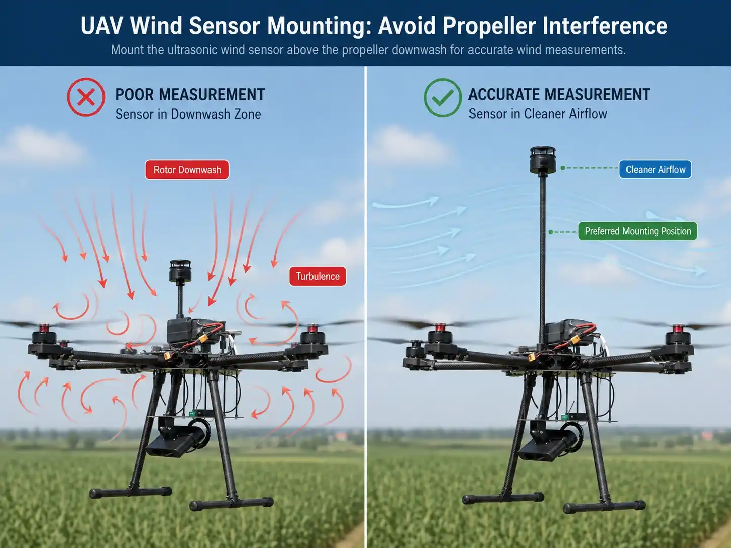
If the wind sensor is installed directly inside this disturbed airflow, the measurement may represent the UAV’s own aerodynamic influence rather than the undisturbed atmospheric wind.
This is one of the most important considerations in UAV wind measurement.
Where Should a Wind Sensor Be Mounted on a UAV?
There is no universal mounting position for every aircraft.
The best position depends on:
- UAV geometry
- Number of rotors
- Propeller diameter
- Flight direction
- Payload configuration
- Sensor size
- Aircraft control system
- Required accuracy
The general objective is to place the sensor where airflow disturbance from the aircraft is minimized.
Possible positions include:
Above the Aircraft
A sensor can be mounted on an elevated support above the UAV body.
This may help move the sensing volume away from some parts of the rotor wake.
However, the mounting structure adds weight and can affect aerodynamics.
Below the Aircraft
Some configurations place the sensor below the UAV.
This may simplify mechanical integration but requires careful analysis of downward rotor airflow.
Forward of the Aircraft
On suitable platforms, positioning the wind sensor away from the main body can help reduce interference.
The design must still consider aircraft movement and structural stability.
For demanding projects, airflow simulation or field calibration may be required to determine the most representative installation position.
Apparent Wind vs. True Atmospheric Wind
Another important point is that a moving UAV does not automatically measure true atmospheric wind.
The sensor experiences relative airflow.
That airflow can include:
- Actual environmental wind
- UAV forward motion
- Vertical movement
- Rotation
- Propeller-induced airflow
Therefore, advanced UAV wind-monitoring systems may combine wind sensor data with information from the aircraft itself.
Possible inputs include:
- GPS ground speed
- Aircraft heading
- IMU data
- Pitch
- Roll
- Yaw
- Vertical velocity
A simplified concept is:
Measured Relative Wind
+
UAV Motion and Orientation Data
↓
Motion Compensation
↓
Estimated Atmospheric Wind Vector
This becomes increasingly important when a project requires accurate mapping of the actual wind field rather than simply recording airflow around the aircraft.
UAV Wind Profiling: Measuring Wind at Different Altitudes
One of the strongest advantages of drone-based wind sensing is vertical profiling.
A UAV can climb through different altitude layers while continuously recording wind data.
For example:
10 m → wind speed and direction
30 m → wind speed and direction
50 m → wind speed and direction
100 m → wind speed and direction
150 m → wind speed and direction
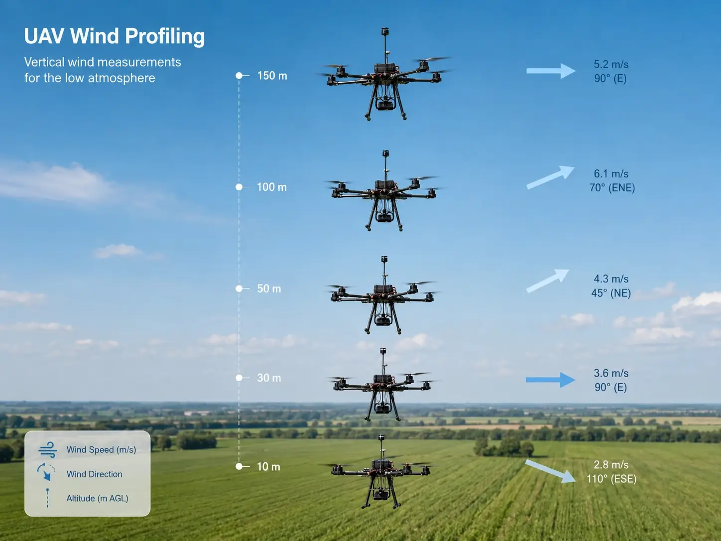
This creates a vertical wind profile.
Such data can be useful for studying:
- Atmospheric boundary layers
- Temperature inversions
- Urban airflow
- Agricultural microclimates
- Pollutant dispersion
- Mountain meteorology
- Wind shear
- Emergency weather conditions
Unlike a tall meteorological tower, the UAV does not require permanent infrastructure at every measurement altitude.
Application 1: Low-Altitude Meteorological Research
Conventional surface weather stations provide excellent long-term ground observations.
Weather balloons provide atmospheric profiles but are generally designed for much higher-altitude measurements and are not always convenient for repeated low-level surveys.
UAVs occupy an interesting space between these two methods.
They can repeatedly sample the lower atmosphere at selected heights.
A drone equipped with a wind sensor may be used together with:
- Air temperature sensors
- Relative humidity sensors
- Pressure sensors
- Gas sensors
- Particulate matter sensors
This allows researchers to examine how local atmospheric conditions vary vertically.
For broader fixed monitoring projects, JW-IoT also provides Ultrasonic Weather Stations for continuous wind and climate observation.
Application 2: Air Pollution and Gas Dispersion Monitoring
Measuring pollutant concentration alone often tells only part of the story.
Suppose a UAV detects an elevated concentration of a gas near an industrial area.
The concentration measurement answers:
What was detected?
Wind information helps answer another question:
Where might the air mass be moving?
Combining gas measurement with wind speed and direction can support studies involving:
- Industrial emissions
- Methane monitoring
- Smoke dispersion
- Dust transport
- Emergency gas releases
- Air quality research
This does not mean wind direction automatically identifies the emission source.
Atmospheric dispersion is affected by turbulence, terrain, thermal conditions, buildings, and many other factors.
But wind measurements provide essential environmental context for interpreting airborne concentration data.
Application 3: Wind Turbine and Renewable Energy Inspection
Wind energy installations often require inspection of:
- Turbine blades
- Towers
- Nacelles
- Transmission infrastructure
- Nearby terrain
UAVs can reduce the need for some manual inspection activities.
When onboard wind information is available, operators can better understand the atmospheric conditions encountered during inspection.
Wind data may also be useful for research surveys around renewable energy facilities.
For permanent ground-based wind monitoring, a fixed Wind Speed Direction Sensor for Wind Energy Monitoring may be more appropriate than an airborne sensor.
The two approaches serve different purposes:
Fixed sensor: continuous long-term reference measurement.
UAV sensor: mobile measurement at different positions or altitudes.
Application 4: Agricultural and Precision Farming Research
Wind affects several agricultural processes.
These include:
- Spray drift
- Evapotranspiration
- Crop ventilation
- Heat transport
- Pollen movement
- Disease dispersion
Ground weather stations provide essential field-level information.
However, UAVs can help researchers investigate whether conditions change above different parts of the crop canopy.
A drone carrying meteorological sensors can survey:
- Orchards
- Large crop fields
- Vineyards
- Plantations
- Research plots
Combining UAV observations with fixed agricultural weather stations can produce a more complete view of the field microclimate.
Application 5: Emergency and Disaster Monitoring
Installing a meteorological mast is not always practical during an emergency.
Examples include:
- Wildfires
- Chemical accidents
- Flood events
- Landslides
- Industrial explosions
- Hazardous gas releases
A UAV can enter areas that may be difficult or dangerous for personnel.
When wind data is combined with cameras, gas sensors, or environmental monitoring instruments, emergency teams can obtain additional information about local conditions.
This can be especially useful when the environment is changing rapidly.
Application 6: Urban Wind Mapping
Cities create complex airflow.
Buildings generate:
- Channeling
- Wake zones
- Vortices
- Turbulence
- Wind acceleration between structures
A single rooftop weather station cannot fully describe these local effects.
UAV-based measurement can help investigate how wind varies around:
- High-rise buildings
- Streets
- Industrial complexes
- Bridges
- Construction sites
- Urban open spaces
The resulting data may support research in urban meteorology, infrastructure engineering, environmental monitoring, and building studies.
UAV Wind Sensor vs. Traditional Cup Anemometer
Both measurement methods have their place.
| Feature | UAV Ultrasonic Wind Sensor | Cup Anemometer + Wind Vane |
| Measurement principle | Ultrasonic | Mechanical rotation |
| Moving measurement parts | No | Yes |
| UAV suitability | High when designed for UAV use | Generally limited |
| Size | Can be very compact | Usually larger |
| Maintenance | Low mechanical maintenance | Bearings and moving components may require attention |
| Mobile applications | Well suited | Less convenient |
| Fixed long-term station | Suitable | Also highly suitable |
| Response to changing airflow | Fast electronic response | Mechanical i |
The choice should therefore be based on application rather than assuming that one technology is universally better.
For a permanent meteorological station, conventional mechanical wind sensors may remain highly effective.
For small mobile platforms, weight, size, vibration resistance, and mechanical simplicity make ultrasonic technology particularly attractive.
How UAV Wind Data Can Be Collected
The wind sensor is only the first part of the monitoring system.
A complete UAV measurement architecture may look like:
UAV Ultrasonic Wind Sensor
↓
Onboard Controller / Flight Computer
↓
Timestamp + GPS + Attitude Data
↓
Local Storage or Telemetry
↓
Ground Station / Cloud Platform
↓
Wind Profile or Mapping Analysis
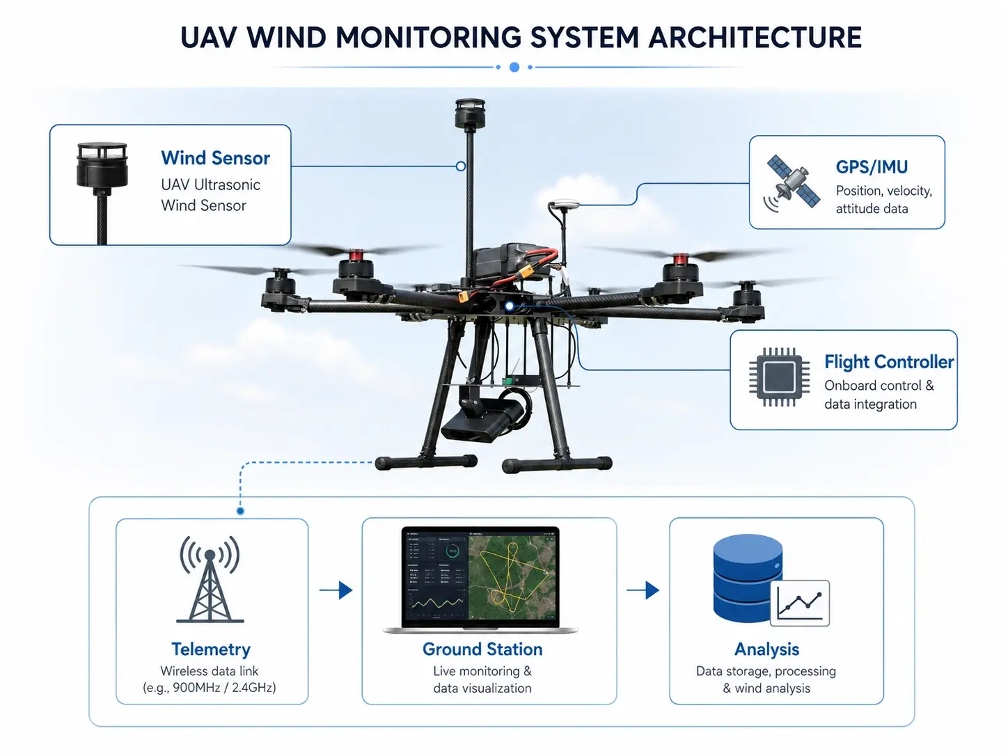
Depending on system design, the wind sensor may connect through a digital communication interface to:
- UAV flight controllers
- Embedded computers
- Data acquisition modules
- Custom payload controllers
The aircraft system can then synchronize wind measurements with position and altitude.
This synchronization is particularly important for mapping applications.
A wind speed value without a corresponding location and altitude has limited value in a UAV survey.
Why Time Synchronization Matters
Imagine that the UAV is moving quickly across a study area.
If the GPS position is recorded at 10:00:01 but the wind measurement is recorded several seconds later without accurate synchronization, the two data points may represent different locations.
For high-resolution surveys, monitoring systems should therefore consider:
- Timestamp accuracy
- Sensor update rate
- GPS synchronization
- Data logging frequency
- Communication latency
The objective is to associate each meteorological measurement with the correct:
Time + Latitude + Longitude + Altitude
For more advanced systems, aircraft orientation can also be recorded.
What Data Should Be Stored During a UAV Wind Survey?
A useful UAV meteorological dataset may include:
- Timestamp
- Latitude
- Longitude
- Altitude
- Wind speed
- Wind direction
- UAV heading
- Ground speed
- Pitch
- Roll
- Yaw
Optional environmental parameters may include:
- Air temperature
- Relative humidity
- Atmospheric pressure
- Gas concentration
- PM2.5 / PM10
- Radiation
This produces a much richer dataset than a simple list of wind measurements.
How to Select a UAV Ultrasonic Wind Sensor
When selecting a sensor, do not evaluate wind range and accuracy alone.
Several platform-level requirements are equally important.
Weight
How much payload can the UAV safely carry?
The sensor weight should be considered together with brackets, cables, controllers, and other instruments.
Sensor Dimensions
Will the sensor fit in a position with acceptable airflow?
A small sensor may provide more mounting flexibility.
Power Consumption
What voltage is available from the UAV?
How much power can the payload draw without significantly reducing flight time?
Wind Measurement Range
The measurement range should match expected environmental conditions and aircraft operation.
Output Interface
The sensor must communicate with the onboard controller or data acquisition system.
Confirm both the physical interface and communication protocol before integration.
Update Rate
Mobile measurement may require faster data updates than conventional long-term weather monitoring.
The required sampling frequency should be determined by the research or operational objective.
Environmental Protection
Depending on the mission, the UAV may encounter:
- Dust
- Humidity
- Light precipitation
- Low temperature
- High temperature
The sensor housing and electronics should be suitable for the intended operating environment.
Operating Altitude
For mountain surveys or high-altitude UAV operations, verify the sensor’s supported operating altitude and environmental limits.
UAV Wind Monitoring System Design Example
A practical environmental UAV configuration might include:
Airborne Layer
- UAV platform
- Ultrasonic wind speed and direction sensor
- Temperature / humidity / pressure sensor
- Optional gas or PM sensor
- GPS and IMU
- Payload controller
Communication Layer
- Serial communication
- UAV telemetry
- Radio link
- Optional cellular communication
Ground Layer
- Ground control station
- Real-time monitoring software
- Data storage
- Flight mission management
Analysis Layer
- Wind profile visualization
- Wind vector mapping
- Altitude comparison
- Environmental parameter correlation
- GIS visualization
Rather than selecting each sensor separately, integrators should design the entire chain from airborne measurement to final data analysis.
Fixed Weather Station or UAV Wind Sensor: Which Should You Use?
In many projects, the answer is not one or the other.
The two systems can complement each other.
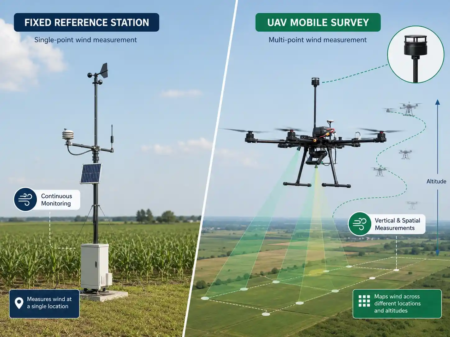
Use a Fixed Weather Station When:
- Continuous monitoring is required
- Long-term climate data is important
- One site needs permanent observation
- Standardized reference measurements are needed
Use UAV Wind Monitoring When:
- Measurements are needed at multiple altitudes
- The site is difficult to access
- Temporary surveys are required
- Spatial wind mapping is important
- A mobile environmental payload is needed
Use Both When:
A particularly useful architecture is:
Fixed Weather Station = Reference Point
UAV Sensor = Mobile Vertical / Spatial Survey
The fixed station provides continuous baseline data while the drone investigates how conditions vary around that reference.
FAQ
1. What is a UAV ultrasonic wind sensor?
A UAV ultrasonic wind sensor is a lightweight wind measurement instrument designed for drones and unmanned platforms. It uses ultrasonic signals rather than mechanical cups or vanes to determine wind speed and wind direction.
2. Why use an ultrasonic anemometer on a drone?
Ultrasonic wind sensors can be compact, lightweight, fast responding, and free of rotating measurement parts. These characteristics make them suitable for UAV platforms where payload weight, vibration, space, and power consumption are important.
3. Can a drone measure wind speed accurately?
Yes, but UAV wind measurement requires careful system design. Sensor placement, rotor downwash, aircraft movement, heading, and attitude can influence the measurement. Applications requiring true atmospheric wind may require motion compensation and calibration.
4. Does the UAV propeller affect wind measurements?
Yes. Multirotor propellers generate significant airflow and turbulence. The wind sensor should be positioned to reduce this interference as much as practical.
5. Can a UAV wind sensor create a vertical wind profile?
Yes. A drone can measure wind speed and direction while ascending through different altitude levels, allowing researchers to build a low-altitude vertical wind profile.
6. Can UAV wind monitoring be used for air pollution studies?
Yes. Wind information can provide useful context for interpreting airborne gas or particulate measurements because pollutant transport is strongly influenced by airflow.
7. Is an ultrasonic UAV wind sensor better than a cup anemometer?
Not in every application. Cup anemometers remain effective for many fixed weather stations. Ultrasonic sensors are particularly attractive for mobile platforms because they can be compact and have no mechanical rotating measurement parts.
8. What information should be recorded with UAV wind data?
For mapping applications, wind data should ideally be synchronized with timestamp, GPS position, altitude, and where necessary UAV heading and attitude information.
From a Wind Sensor to an Airborne Meteorological Platform
The real value of a UAV ultrasonic wind sensor is not simply that it measures wind from a drone.
Its greater value comes from enabling meteorological measurements to move through three-dimensional space.
A fixed station answers:
What is the wind doing here?
A UAV monitoring system can investigate:
What is the wind doing here, at this altitude, at this moment?
That distinction opens the door to applications in atmospheric research, environmental monitoring, industrial inspection, agriculture, emergency response, urban meteorology, and renewable energy.
For system integrators and UAV manufacturers, successful deployment depends on more than selecting a sensor with the correct wind range.
The complete project should consider:
- Sensor weight
- Power consumption
- Mounting location
- Rotor airflow interference
- Aircraft motion
- GPS and IMU synchronization
- Communication interfaces
- Data logging
- Environmental protection
- Final analysis requirements
When these elements are designed together, a small UAV can become a flexible platform for low-altitude wind and environmental monitoring.
Need a UAV Wind Monitoring Configuration?
JW-IoT provides compact ultrasonic wind sensing and environmental monitoring hardware for UAV, meteorological, industrial, and IoT applications.
For drone-based projects, configuration can be evaluated according to:
- UAV type
- Maximum payload
- Required wind range
- Installation position
- Power supply
- Communication interface
- Required sampling rate
- Flight altitude
- Additional meteorological parameters
- Ground-station or data-platform requirements
Explore the UAV Ultrasonic Wind Speed Direction Sensor or contact JW-IoT with your UAV platform specifications to discuss a suitable airborne wind monitoring configuration.