+86 13520127780
  info@jingelway.com








What Is a Flood Monitoring System and How Does It Work?
Release time: 2026-07-16
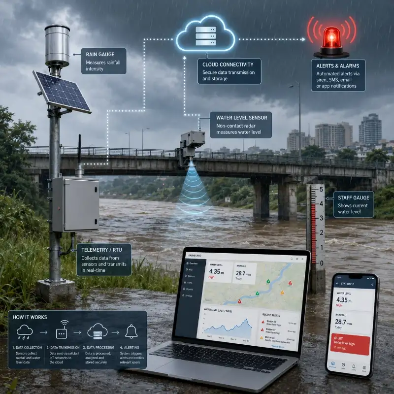
A flood monitoring system consists of sensors, communication modules, data platform, cameras, and warning devices for real-time monitoring of rainfall and rising water levels.
The system collects field data, transmits measurements to the cloud platform, compares sensor readings to alarm thresholds, and triggers warnings when flooding may occur.
Instead of just having one water level sensor, a flood warning system can provide more comprehensive information by combining rainfall data, river level, reservoir level, flow conditions, weather parameters, and site images to help emergency responders determine how fast conditions are changing, which areas may be affected, and how soon they need to react.
For projects that require rainfall, water level, video surveillance, remote communication, and automated alarms, explore the complete flood monitoring system from JW-IoT.
What Is a Flood Monitoring System?
Put simply, a flood monitoring system detects rainfall and rising water levels before flooding becomes imminent or dangerous.
- A flood monitoring system typically performs four basic functions:
- Measure rainfall, water level, water flow, or other environmental parameters.
- Transmit collected data from remote locations.
- Analyze monitored conditions.
Send notifications when thresholds are breached.
Project requirements will determine the number of stations needed and which river basins, cities, reservoirs, mountains, or drainage networks should be monitored.
Flood Monitoring System vs Flood Detection System
Flood monitoring system, flood detection system, and flood warning system are three terms that are frequently used interchangeably.
However, there are some differences in how each system functions.
| System type | Main function |
| Flood monitoring system | Continuously collects and displays rainfall, water level, flow, and site data |
| Flood detection system | Identifies abnormal conditions that may indicate flooding |
| Flood warning system | Sends alerts when monitored conditions reach predefined risk levels |
| Flood early warning system | Combines monitoring, risk analysis, communication, and emergency notification |
In practice, an IoT flood monitoring solution would likely have all four functions.
Monitoring stations would be deployed to monitor rainfall and water levels. Condition monitoring would detect sudden changes in water level or rainfall intensity. Water level alarms would determine if monitored conditions pose a potential flood risk. Automatic alarms would allow alerts to be sent across multiple channels.
What Parameters Are Monitored?
The monitored parameters depend on the project’s location, type of flooding, water bodies being monitored, available network coverage, and emergency response needs.
Rainfall
A rain gauge measures precipitation amount, rainfall intensity, and accumulated rainfall. This information helps operators identify heavy storms and evaluate how much water may enter rivers, drainage channels, reservoirs, or low-lying urban areas.
Examples of rainfall parameters include:
- Rainfall per minute
- Hourly rainfall
- Accumulated rainfall
- Rainfall intensity
- Storm duration
- Daily rainfall
Rainfall data can help spot heavy storms and quantify how much rain fell. Rainfall monitoring is critical for flash flood warning systems because runoff can become dangerous before a river reaches its peak level.
Water Level
A water level monitoring system allows you to measure whether a river, reservoir, canal, drainage channel, culvert, or road is about to flood.
A water level monitoring system can use radar, ultrasonic, pressure, or other level sensing technologies to measure water continuously.
Examples of water level parameters include:
- Current water level
- Rate of rise
- Distance to warning level
- Distance to overflow level
- Historical highest level
- Length of time above a threshold
Rate of rise is an important parameter because a river rising quickly may require more immediate attention than a slowly rising river. If the water level is approaching too close to the top, an alarm can be triggered to allow for earlier action.
Water Flow and Velocity
Water velocity and flow rate help determine how quickly water is moving through a river, canal, drainage outlet, or open channel.
These parameters may be used to:
- Estimate discharge
- Evaluate runoff conditions
- Detect blocked or overloaded channels
- Support reservoir operation
- Improve flood forecasting models
Flow monitoring is not required at every station, but it can provide valuable information in river basin, hydrology, dam, and drainage projects.
Weather Conditions
Some flood monitoring stations also measure:
- Air temperature
- Atmospheric pressure
- Wind speed
- Wind direction
- Relative humidity
- Solar radiation
These measurements provide additional environmental context and may be useful when the flood monitoring network is integrated with a weather station or broader hydrometeorological system.
Soil Moisture
In mountain catchments, agricultural areas, and landslide-prone regions, soil moisture can help indicate how much additional rainfall the ground can absorb.
When soil is already saturated, even moderate rainfall may create rapid surface runoff. Soil moisture data can therefore improve flash flood and slope risk assessment.
Images and Video
Cameras provide visual confirmation of field conditions.
They may be installed near:
- Rivers
- Bridges
- Culverts
- Underpasses
- Reservoir spillways
- Drainage outlets
- Urban intersections
- Mountain streams
Images help operators verify whether high sensor readings are caused by actual flooding, floating debris, sensor obstruction, construction activity, or another local condition.
Main Components of a Flood Monitoring System
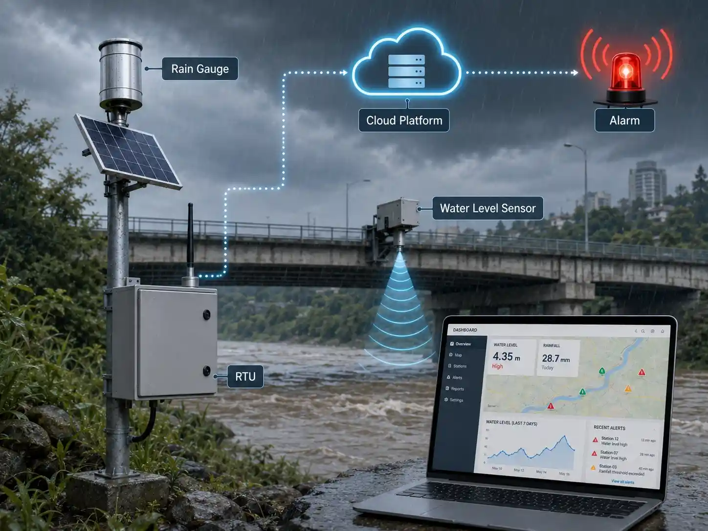
A complete flood monitoring system normally includes five system layers.
1. Monitoring Sensors
Flood monitoring sensors collect physical measurements from the field.
Typical sensors include:
- Tipping bucket or optical rain gauges
- Radar water level sensors
- Ultrasonic water level sensors
- Pressure water level sensors
- Water velocity sensors
- Flow meters
- Soil moisture sensors
- Weather sensors
- Cameras
Sensor selection will vary based on your monitoring needs and the environment conditions at each station.
For example, solar radiation and air temperature may be helpful for some projects, but not others. It would not be practical to use wireless sensors when installing water level sensors below a bridge.
2. Data Logger or Remote Terminal Unit
The data logger or remote terminal unit collects signals from the sensors.
Its functions may include:
- Sensor data acquisition
- Data storage
- Time stamping
- Protocol conversion
- Local threshold processing
- Power management
- Communication control
- Equipment status monitoring
Common sensor interfaces include RS485 Modbus, SDI-12, pulse, analog voltage, and 4–20 mA.
Some remote terminal units can continue storing data when communication is interrupted and upload the missing records after the network connection is restored.
3. Communication Network
Remote flood monitoring stations require reliable data transmission.
Depending on the site, communication may use:
- 4G LTE
- NB-IoT
- LoRaWAN
- Ethernet
- Wi-Fi
- Radio
- Satellite communication
- RS485 cable
- A combination of primary and backup networks
JW-IoT communication devices support technologies such as LoRaWAN, 4G, Ethernet, RS485, MQTT, and gateway connectivity for transmitting field data to remote platforms.
For remote rivers, mountain catchments, and rural areas, network availability should be tested before equipment is selected. Critical warning stations may require a backup communication method.
4. Cloud or Server Platform
The monitoring platform receives, stores, processes, and displays field data.
A typical platform provides:
- Real-time dashboards
- Monitoring station maps
- Historical data curves
- Alarm records
- Equipment status
- Data export
- User permissions
- Camera access
- Mobile access
- API integration
The platform may be cloud-based or deployed on a private server, depending on cybersecurity, ownership, government, and project requirements.
5. Warning Equipment
When risk thresholds are reached, the system can activate one or more warning channels.
These may include:
- SMS messages
- Email alerts
- Mobile application notifications
- Platform pop-up alarms
- Audible and visual alarms
- Sirens
- LED display boards
- Radio broadcasts
- Relay-controlled equipment
- Third-party emergency platforms
A reliable flood early warning system should use more than one notification channel, especially for high-risk locations.
How Does a Flood Monitoring System Work?
Below are 6 steps that explain how a flood monitoring system works:
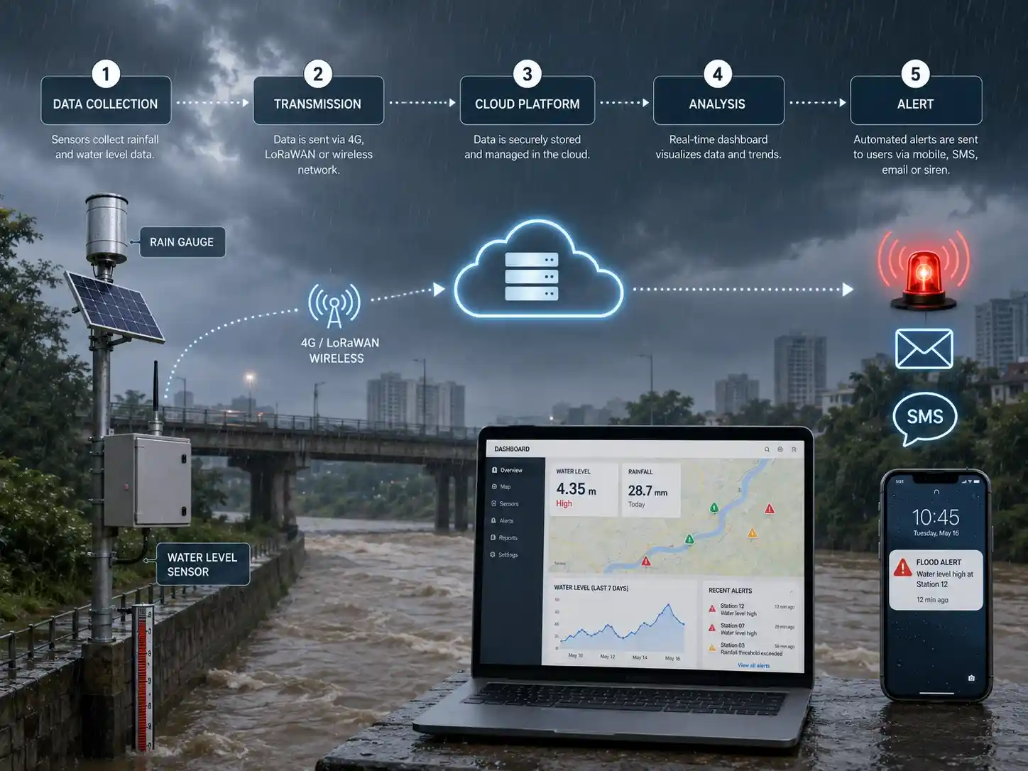
Step 1: Sensors Measure Field Conditions
Rainfall is measured by rain gauges while water level sensors measure rivers, reservoir water levels, flooded roads, drainage channels, or any other areas where flooding may occur.
Sensors can automatically collect data every minute, 5 minutes, 30 minutes, hourly, or other time interval. Some systems detect when rainfall is occurring and temporarily switch to a faster reporting schedule.
Step 2: The Data Logger Collects Sensor Signals
The field data logger reads the connected sensors and converts their signals into structured monitoring data.
It may also calculate:
- Accumulated rainfall
- Water level change
- Rate of rise
- Battery voltage
- Communication status
- Sensor fault status
Step 3: Data Is Transmitted to the Platform
The communication device sends the collected data to a cloud platform or control center.
Common protocols include:
- MQTT
- Modbus
- TCP/IP
- HTTP
- JSON-based APIs
- Industry-specific hydrology protocols
For sites without a stable public network, a LoRaWAN gateway, private radio link, or satellite connection may be used.
Step 4: The Platform Displays and Analyzes the Data
The platform presents current readings, historical trends, map locations, alarm status, and equipment health.
Operators can compare rainfall and water level data from multiple stations to understand how a storm is moving through a catchment or drainage network.
Step 5: Alarm Rules Are Evaluated
The system compares current measurements with predefined thresholds.
An alarm may be triggered by:
- High water level
- Rapid water level rise
- High rainfall intensity
- Accumulated rainfall
- High flow velocity
- Sensor failure
- Communication interruption
- Low battery voltage
- Cabinet intrusion
- Multiple conditions occurring together
Step 6: Warnings Are Sent
When an alarm condition is confirmed, the system sends notifications to the appropriate users.
Different risk levels can be assigned to different actions. For example:
- A low-level alert may notify monitoring personnel.
- A medium-level alert may notify local emergency managers.
- A high-level alert may activate sirens or public warning equipment.
How Do Flood Alarm Thresholds Work?
Alarm thresholds define when the system should treat a measurement as potentially dangerous.
A basic water level warning system may use three or four levels.
| Alarm level | Example meaning | Typical response |
| Advisory | Water is above the normal operating range | Increase observation frequency |
| Warning | Water is approaching a critical level | Notify responsible personnel |
| Critical | Flooding may occur soon | Begin emergency response |
| Emergency | Water has reached or exceeded a dangerous level | Activate public warnings and evacuation procedures |
Thresholds should not be copied directly from another project.
They should be determined using:
- Historical flood records
- River cross-section data
- Local drainage capacity
- Reservoir operating rules
- Road or bridge elevation
- Community exposure
- Government warning standards
- Emergency response time
Single-Parameter Alarms
A single-parameter alarm is triggered by one measurement, such as water level exceeding 5 meters.
This method is simple but may produce unnecessary alarms if local conditions are complex.
Multi-Parameter Alarms
A multi-parameter alarm uses several conditions together.
For example:
- Hourly rainfall exceeds the warning value.
- The river level is rising rapidly.
- Soil moisture indicates saturated ground.
- Upstream stations are also reporting rising water.
This method can provide a more reliable assessment of developing flood conditions.
Rate-of-Change Alarms
A rate-of-change alarm is triggered when a parameter changes too quickly.
For example, a river may still be below the official warning level but rising at 20 centimeters every ten minutes. The rapid change may justify an early warning before the fixed threshold is reached.
Common Flood Monitoring Applications
1. River Flood Monitoring
River stations continuously monitor rainfall, water level, velocity, and images.
Data from upstream and downstream stations helps operators understand flood movement and identify locations where water may exceed safe levels.
2. Flash Flood Warning
Flash flood systems are commonly installed in mountain valleys, small catchments, tourist areas, villages, and roads near steep terrain.
Because flash floods can develop quickly, these systems require:
- Short monitoring intervals
- Fast data transmission
- Reliable power
- Local sirens
- Upstream rainfall stations
- Rapid water level detection
3. Urban Waterlogging Monitoring
Urban flood monitoring focuses on roads, tunnels, underpasses, drainage outlets, low-lying intersections, parking areas, and underground spaces.
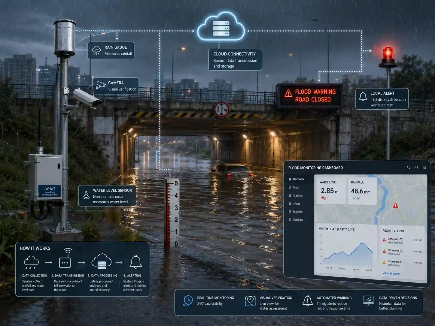
The system may combine:
- Road water level sensors
- Rain gauges
- Cameras
- Drainage pump status
- Manhole level sensors
- LED warning displays
- Traffic barriers
4. Reservoir and Dam Monitoring
Reservoir systems monitor water level, rainfall, inflow, discharge, spillway conditions, and gate operation.
The data supports safe reservoir management and helps operators respond to extreme rainfall or abnormal water level changes.
5. Drainage Channel Monitoring
Monitoring stations installed along drainage channels and culverts can identify rising water, restricted flow, blockages, and capacity problems.
This is useful for smart cities, industrial parks, airports, highways, and large construction sites.
6. Coastal and Tidal Flood Monitoring
Coastal systems monitor tide level, storm surge, waves, rainfall, wind, and drainage conditions.
They are often integrated with meteorological and ocean monitoring networks.
7. Construction and Mining Sites
Large construction sites, open-pit mines, tunnels, and underground engineering projects may face flooding caused by rainfall, groundwater, drainage failure, or pump malfunction.
Monitoring systems help protect workers, equipment, and temporary structures.
IoT Flood Monitoring Architecture
An IoT flood monitoring system connects field sensors with remote software and warning equipment.
A typical architecture is:
Flood monitoring sensors → data logger or RTU → communication network → cloud or private server → dashboard and alarm system
The IoT architecture enables:
- Remote access
- Multi-station management
- Historical trend analysis
- Automatic alarms
- Equipment diagnostics
- API integration
- Reduced manual inspection
- Faster emergency response
However, IoT connectivity does not automatically make a system reliable. Sensor installation, power supply, communication redundancy, platform configuration, maintenance, and alarm procedures are equally important.
How to Select a Suitable Flood Monitoring System
Define the Flood Risk
First identify the type of flooding the system must monitor.
Possible risks include:
- River flooding
- Flash flooding
- Urban waterlogging
- Reservoir overflow
- Drainage failure
- Coastal flooding
- Construction-site flooding
Different risks require different sensor locations and alarm strategies.
Identify the Required Parameters
Not every station needs every sensor.
A basic station may monitor rainfall and water level. A more complete station may include velocity, weather, soil moisture, video, and local warning devices.
Select parameters that directly support operational decisions.
Evaluate the Site Conditions
Important site factors include:
- River width
- Sensor mounting height
- Expected water level range
- Sediment and floating debris
- Network coverage
- Solar exposure
- Flood accessibility
- Lightning risk
- Temperature and humidity
- Vandalism risk
Site conditions affect enclosure selection, sensor technology, mounting structure, power supply, and communication method.
Select an Appropriate Water Level Sensor
Non-contact radar or ultrasonic sensors can reduce direct contact with floodwater, sediment, and debris.
Pressure sensors may be suitable for protected installations but require contact with the water and may need more frequent cleaning.
Sensor selection should consider:
- Measurement range
- Accuracy
- Blind zone
- Beam angle
- Water surface conditions
- Installation distance
- Maintenance requirements
- Environmental protection rating
Choose Reliable Communication
Communication technology should be selected according to distance, terrain, network coverage, data volume, and response requirements.
4G may be suitable where cellular coverage is stable. LoRaWAN may be useful for multiple nearby stations. Satellite communication may be required for critical sites outside public network coverage.
High-risk projects may use both primary and backup communication channels.
Plan the Power Supply
Remote stations often use solar panels and rechargeable batteries.
The power system should support:
- Sensor operation
- Data logging
- Communication
- Cameras
- Warning devices
- Several days of low sunlight
- Increased reporting during storms
Power consumption should be calculated for the complete station, not only for the sensors.
Define the Alarm Logic
Before deployment, determine:
- Who receives each alarm
- Which thresholds apply
- How alarms are verified
- What actions follow each alarm
- Whether local warning equipment is activated
- How false alarms are handled
- How alarm records are stored
A flood monitoring system provides information, but emergency procedures determine how that information is used.
Consider Integration Requirements
The system may need to connect with:
- Government hydrology platforms
- Emergency management systems
- SCADA systems
- Smart city platforms
- Weather databases
- Drainage control systems
- GIS maps
- Mobile applications
- Third-party APIs
Confirm data ownership, protocol, server deployment, cybersecurity, and API requirements before selecting equipment.
Plan Maintenance
Flood monitoring equipment operates in demanding outdoor environments.
A maintenance plan should include:
- Sensor inspection
- Rain gauge cleaning
- Solar panel cleaning
- Battery testing
- Camera inspection
- Communication testing
- Alarm testing
- Calibration
- Firmware updates
- Mounting structure inspection
Systems located in flood-prone areas should be designed so that maintenance can be completed safely.
What Equipment Is Needed for a Basic Flood Monitoring Station?
A basic station normally includes:
- Rain gauge
- Water level sensor
- Data logger or RTU
- 4G, LoRaWAN, radio, or satellite communication device
- Solar panel and battery
- Outdoor enclosure
- Mounting structure
- Cloud monitoring platform
- Alarm notification function
Optional equipment may include:
- Camera
- Flow velocity sensor
- Weather sensors
- Soil moisture sensor
- Siren
- LED display
- Backup communication
- Lightning protection
- Local data display
Benefits of a Flood Monitoring System
A properly designed system can provide several operational benefits.
Earlier Risk Identification
Continuous rainfall and water level data helps identify developing flood conditions earlier than periodic manual inspections.
Faster Emergency Response
Automated alarms reduce the delay between detecting a dangerous condition and notifying responsible personnel.
Remote Monitoring
Operators can monitor multiple rivers, reservoirs, roads, and drainage points without traveling to every site.
Better Historical Analysis
Stored data supports flood analysis, infrastructure planning, threshold adjustment, and post-event reporting.
Improved Equipment Visibility
The platform can monitor battery voltage, communication status, sensor health, and station availability.
Scalable Deployment
Additional monitoring stations, sensors, cameras, and warning devices can be added as the project expands.
Limitations to Consider
A flood monitoring system cannot prevent every flood.
Its effectiveness depends on:
- Correct sensor selection
- Proper installation
- Reliable communication
- Stable power supply
- Suitable alarm thresholds
- Regular maintenance
- Clear emergency procedures
- Timely human response
Sensors can also be affected by debris, sediment, waves, condensation, lightning, damaged cables, poor mounting, or communication failure.
For this reason, critical flood warning projects should use equipment status monitoring, redundant communication, multiple alarm channels, and periodic field verification.
FAQ
1. What is the main purpose of a flood monitoring system?
The main purpose is to collect real-time rainfall, water level, flow, and site data so that rising flood risk can be detected and communicated before conditions become dangerous.
2. What sensors are used in flood monitoring?
Common flood monitoring sensors include rain gauges, radar or ultrasonic water level sensors, pressure level sensors, flow velocity sensors, soil moisture sensors, weather sensors, and cameras.
3. How does a flood warning system send alerts?
Alerts can be sent through SMS, email, mobile applications, cloud platforms, sirens, LED displays, radio systems, or third-party emergency platforms.
4. Can a flood monitoring system work without cellular coverage?
Yes. Depending on the site, the system can use LoRaWAN, private radio, Ethernet, satellite communication, or a combination of primary and backup networks.
5. How often is flood monitoring data collected?
Data may be collected every few seconds, every minute, every five minutes, or at longer intervals. During heavy rainfall or rapidly rising water, the reporting frequency can be increased.
6. What is the difference between flood monitoring and flood forecasting?
Flood monitoring measures current field conditions. Flood forecasting uses monitoring data, weather forecasts, hydrological models, and historical information to estimate future flood conditions.
7. Can JW-IoT provide customized flood monitoring equipment?
Yes. JW-IoT can combine rainfall sensors, water level sensors, communication devices, data acquisition equipment, cameras, cloud platforms, and warning devices according to site and project requirements.
8. Can JW-IoT integrate flood monitoring data into an existing platform?
Integration may be supported through communication protocols, MQTT, Modbus, TCP/IP, APIs, or customized data interfaces, depending on the existing platform and project specifications.
9. Is a camera necessary for every monitoring station?
No. Cameras are useful for visual verification, but they are not required at every station. They are most valuable at high-risk locations such as bridges, roads, underpasses, spillways, and drainage outlets.
Conclusion
A flood monitoring system combines sensors, data acquisition, communication, software, and warning equipment to provide continuous information about developing flood conditions.
The most effective systems do more than detect a high water level. They combine rainfall, water level trends, flow conditions, site images, equipment status, and well-designed alarm rules to help operators make faster and more informed decisions.
System design should begin with the local flood risk, required response time, site conditions, communication coverage, and emergency procedures. Once these requirements are clear, suitable sensors and communication technologies can be selected for each monitoring location.
For rivers, reservoirs, urban drainage systems, mountain catchments, roads, and other flood-prone areas, JW-IoT provides configurable sensors, communication devices, remote monitoring platforms, and complete flood monitoring system solutions.