+86 13520127780
  info@jingelway.com








Nepal Flash Flood Tragedy Highlights the Growing Importance of Mountain Flood Early Warning Systems
Release time: 2026-08-27
Deadly Flash Flood in Nepal Raises New Concerns Over Mountain Disaster Risk
A devastating flash flood struck Rasuwa District in northern Nepal on August 26, 2026, once again drawing global attention to the growing vulnerability of mountainous regions to sudden hydrological and geological disasters.
According to an update from Nepal Police, the death toll had risen to 270 as of 13:30 local time on August 27, while search and rescue operations were continuing. Because emergency operations remain underway, casualty and missing-person figures may continue to change.
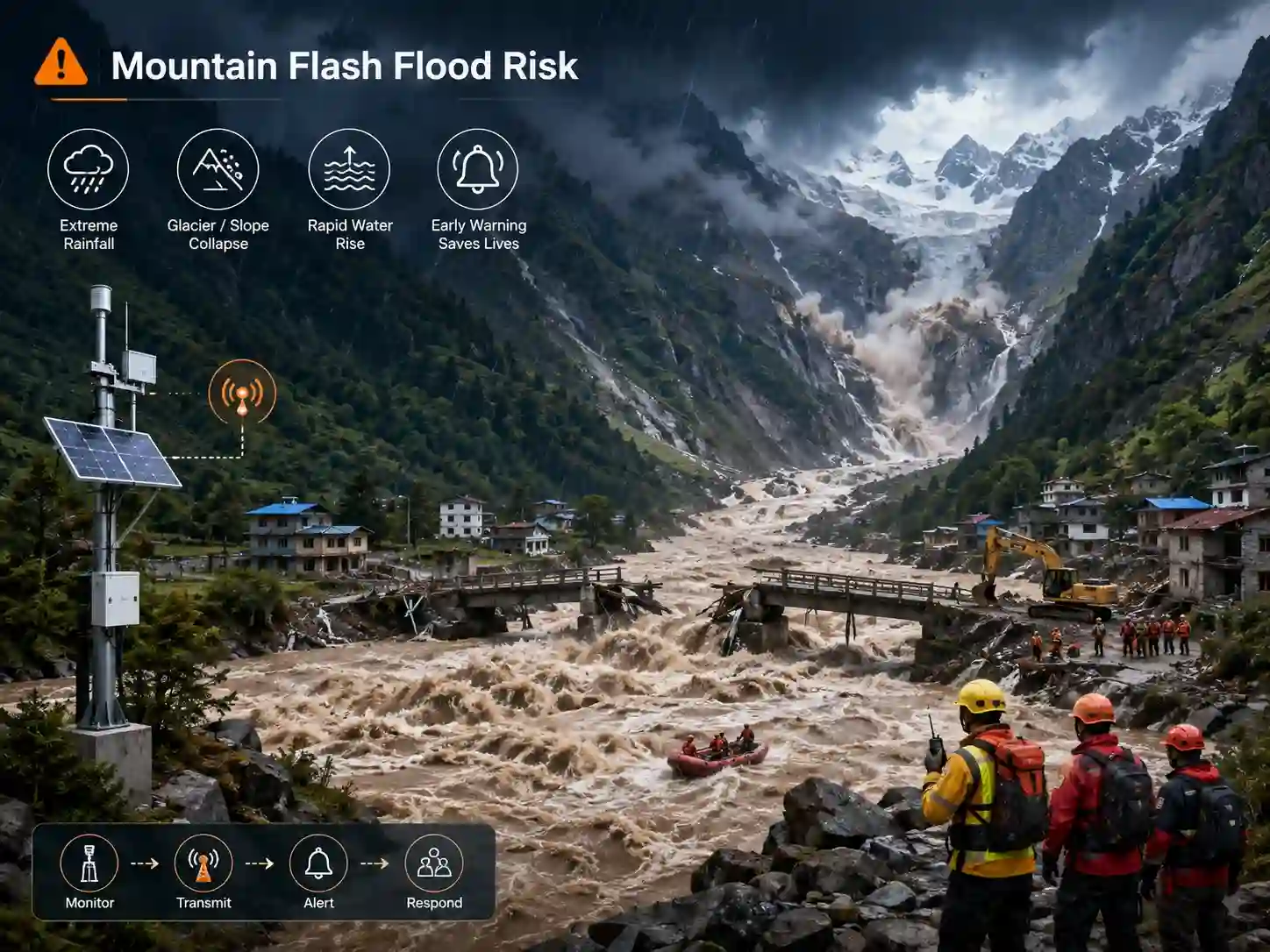
Current reporting indicates that a major glacial collapse triggered a landslide and debris flow, producing a destructive surge of water, mud and debris through communities along the Nepal–Tibet border. Roads, bridges and other infrastructure were damaged, further complicating emergency rescue operations.
The tragedy is first and foremost a humanitarian disaster.
It also highlights a broader challenge faced by mountainous communities around the world:
When floods, landslides, glacier-related hazards and debris flows can develop within a very short period, how can communities obtain actionable warning information before disaster reaches populated areas?
Climate Change Is Reshaping Risk in Mountain Regions
It is important not to automatically attribute any individual flood or landslide solely to climate change without scientific attribution studies.
However, the broader trend is increasingly clear.
According to the World Meteorological Organization’s State of the Climate in Asia 2025, Asia has been warming faster in recent decades than in earlier periods, while glaciers across High Mountain Asia continue to retreat.
All 23 monitored glaciers in High Mountain Asia lost mass during the 2025 glaciological year. WMO also reported multiple glacier collapses and glacial lake outburst floods during the year and emphasized the importance of early warning systems in reducing disaster impacts.
The Intergovernmental Panel on Climate Change also identifies mountain regions as particularly vulnerable to interconnected hazards.
The IPCC notes that changes associated with glacial retreat, slope instability and heavy precipitation can influence flood and landslide activity, while extreme precipitation in major mountain regions is projected to increase in many areas.
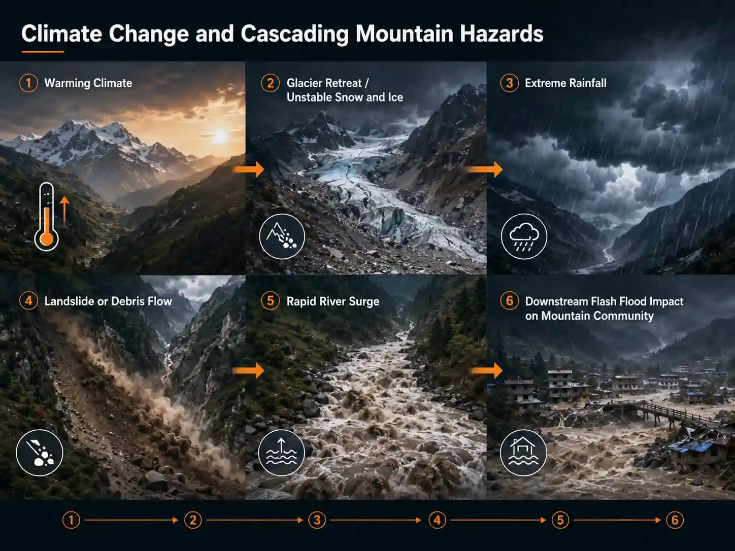
This creates a complex risk environment in which several processes may interact:
Climate warming → glacier and snow changes → unstable slopes or glacial lakes → extreme rainfall or collapse events → landslides and debris flows → rapidly rising rivers → downstream flash floods
For communities located downstream, the final flood may arrive much faster than conventional weather information alone can indicate.
Why Mountain Flash Floods Are Especially Dangerous
A flash flood is not simply a larger version of an ordinary river flood.
In steep mountain catchments, water can travel rapidly through narrow valleys and river channels. Heavy rainfall, landslides, glacial lake releases or natural dam failures may produce sudden increases in discharge and water level.
In some situations, floodwater may also carry:
- rocks
- sediment
- trees
- damaged structures
- vehicles
- other debris
This combination can dramatically increase destructive force.
The available response window may therefore be measured not in days, but sometimes in hours or even minutes.
That is why mountain disaster prevention increasingly requires continuous field monitoring rather than relying only on regional weather forecasts.
What Is a Flash Flood Early Warning System?
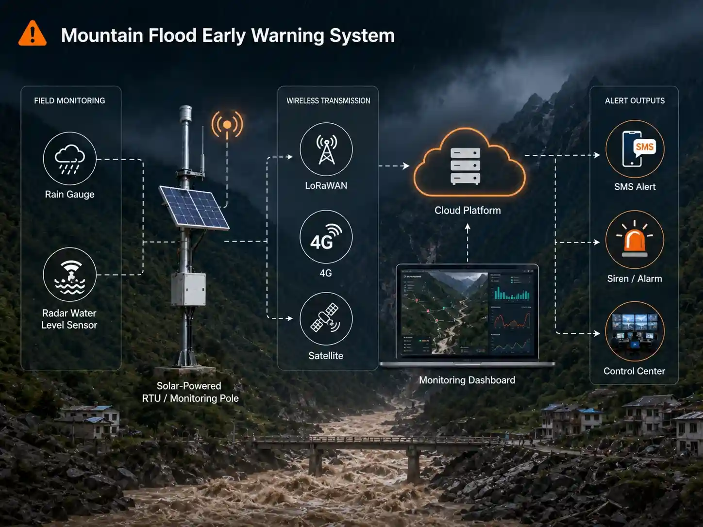
A flash flood early warning system is a distributed monitoring network that continuously observes rainfall, upstream water levels and other environmental conditions, transmits the data to a monitoring platform, and generates alerts when predefined or model-based risk thresholds are reached.
A typical system may include:
Rainfall Monitoring
↓
Upstream River Level Monitoring
↓
RTU / Data Logger
↓
4G / LoRaWAN / NB-IoT / Satellite Communication
↓
Cloud or Government Monitoring Platform
↓
Threshold Analysis
↓
SMS / App / Siren / Control-Center Warning
The objective is not to predict every disaster perfectly.
The objective is to detect dangerous changes as early as possible and convert field data into additional decision-making time.
Learn more about how a complete system works:
Flood Monitoring System – How It Works
1. Rainfall Monitoring: Detecting the Trigger
Rainfall is one of the most important variables in many mountain flood and landslide warning systems.
A rain gauge installed within an upstream catchment can continuously record rainfall intensity and accumulated precipitation.
Instead of knowing only that “heavy rain is occurring,” emergency managers can monitor questions such as:
- How much rainfall has accumulated?
- How quickly is rainfall intensity increasing?
- Has a warning threshold been exceeded?
- Is one catchment receiving significantly more rainfall than surrounding areas?
Distributed rain gauges are particularly useful in mountainous terrain because rainfall may vary significantly across relatively short distances.
For this reason, a flood monitoring network often uses multiple monitoring points rather than a single weather station.
2. River Water Level Monitoring: Detecting What the Catchment Is Doing
Rainfall tells operators what is entering a catchment.
River level tells them how the catchment is responding.
For flash flood warning projects, continuous upstream water-level monitoring can reveal:
- rapidly rising river levels
- abnormal rate of water-level change
- threshold exceedance
- possible upstream blockage or release events
- movement of a flood wave toward downstream communities
Non-contact radar technology can be particularly useful in flood-prone rivers because the instrument does not need to remain submerged in fast-moving water.
JW-IoT’s integrated radar water level gauge is designed for river, reservoir, hydrological and flood-warning applications and can support remote data transmission depending on configuration.
Integrated Radar Water Level Gauge for Hydrology and Flood Monitoring
3. Rate of Rise Can Be as Important as Absolute Water Level
One important lesson in flash flood monitoring is that the absolute water level is not always the only useful indicator.
Consider two situations.
River A:
Water level rises 20 cm over six hours.
River B:
Water level rises 80 cm within 15 minutes.
Even if both rivers remain below the same absolute alarm level, River B may indicate a much more rapidly developing event.
Modern flood-warning platforms can therefore evaluate not only:
Water Level > Threshold
but also:
Rate of Rise > Threshold
Combining these parameters can help emergency teams identify unusual hydrological behavior earlier.
4. Upstream Monitoring Creates Valuable Warning Time
In mountain environments, sensor placement can be as important as sensor accuracy.
If the only river-level station is located directly beside a village, detecting a flood at that point may provide very little evacuation time.
A more effective approach is often to establish monitoring points farther upstream.
For example:
Upstream Catchment
→ Rain Gauge
→ Radar Water Level Sensor
Midstream
→ River Level Monitoring
Downstream Community
→ Warning Station
→ Siren / Display / Emergency Notification
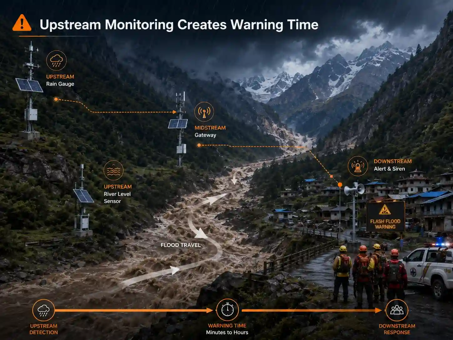
When upstream abnormal conditions are detected, the system can transmit the information immediately to a central platform.
The distance between the monitoring point and the exposed community can effectively become part of the available warning window.
5. Communication Is Critical in Remote Mountain Areas
Many flood-prone catchments are located in areas where conventional infrastructure is limited.
A monitoring station may need to operate:
- kilometers away from towns
- without grid electricity
- in deep valleys
- under severe weather conditions
- with unstable mobile-network coverage
As a result, mountain flood monitoring systems often require flexible communication architectures.
Depending on local infrastructure, these may include:
4G / LTE
Suitable where cellular coverage is reliable.
LoRaWAN
Useful for connecting multiple low-power monitoring nodes to a gateway.
NB-IoT
Applicable where compatible operator networks are available.
Satellite Communication
Can provide an alternative communication path for extremely remote or critical locations.
For important warning systems, communication redundancy should also be considered so that the loss of one network does not automatically result in the loss of critical field information.
6. Solar Power Enables Monitoring Beyond the Grid
Some of the locations where flood monitoring is needed most are the locations where power infrastructure is weakest.
Remote stations can therefore combine:
Solar Panel + Battery + Low-Power Sensors + RTU + Wireless Communication
This makes continuous monitoring possible in mountain valleys, remote river basins and other off-grid locations.
System designers should evaluate power consumption, winter solar conditions, battery autonomy and transmission intervals before deployment.
From Monitoring Data to an Actual Warning
Installing sensors alone does not create an early warning system.
An effective architecture requires data to move through the entire chain:
Sense → Transmit → Analyze → Alert → Respond
For example:
Level 1 — Normal
Rainfall and river levels remain within normal operating ranges.
Level 2 — Attention
Rainfall accumulation or river levels begin approaching predefined thresholds.
Level 3 — Warning
Rapid water-level rise or intense rainfall indicates potentially dangerous conditions.
Level 4 — Emergency
Critical thresholds are reached and configured emergency procedures are activated.
Warnings may then be distributed through:
- emergency-management platforms
- SMS
- mobile applications
- sirens
- speakers
- LED information boards
- control centers
- third-party APIs
The warning thresholds should be established using local hydrological conditions, historical events, terrain and government disaster-management procedures rather than simply applying the same values to every catchment.
Flood Monitoring Should Be Part of a Multi-Hazard Strategy
The Nepal disaster also illustrates why mountainous regions should not consider flooding, landslides and glacier-related hazards as completely separate problems.
These hazards can form a cascading chain.
For example:
Extreme precipitation
→ slope failure
→ landslide
→ blocked river
→ temporary natural dam
→ dam failure
→ downstream flash flood
Or:
Glacier collapse
→ debris flow
→ river surge
→ downstream flooding
Monitoring only one environmental parameter may therefore provide an incomplete picture.
Depending on the project, a broader disaster-monitoring network may combine:
- rainfall
- river water level
- flow velocity
- soil moisture
- meteorological parameters
- ground displacement
- video surveillance
- reservoir or glacial lake level
- communication gateways
- remote warning terminals
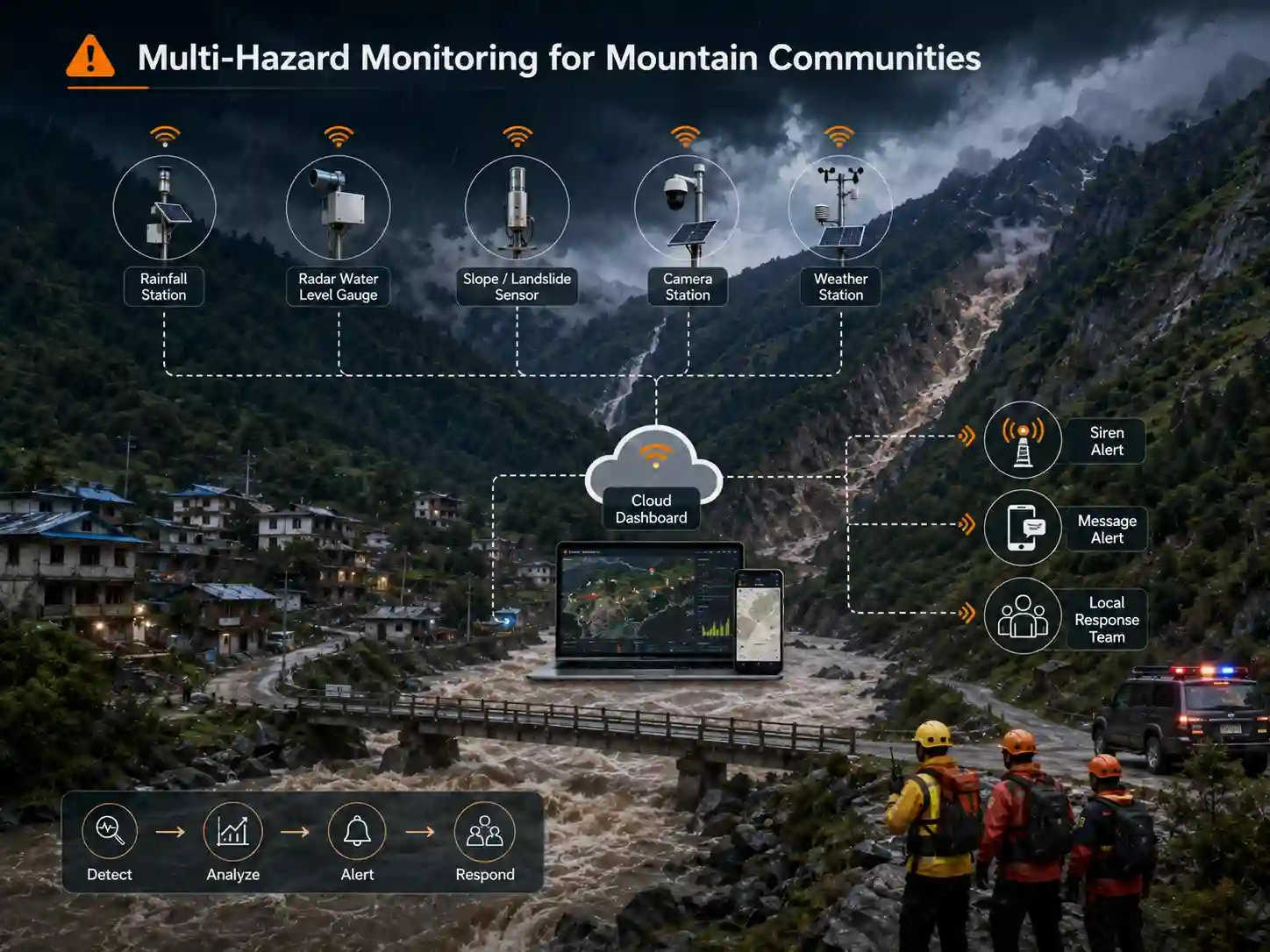
This is one reason integrated environmental IoT systems are becoming increasingly important for disaster-risk management.
Explore JW-IoT’s broader water and environmental monitoring solutions:
Smart Water & Environmental Monitoring Solutions
Early Warning Cannot Prevent the Hazard—but It Can Support Earlier Action
No monitoring technology can eliminate extreme rainfall, glacier collapse, landslides or flash floods.
Nor should an IoT monitoring system be presented as a guarantee that casualties can always be prevented.
Its value lies elsewhere.
A properly designed monitoring and early warning system can help authorities:
- identify abnormal environmental changes earlier
- continuously monitor remote high-risk areas
- reduce dependence on manual observation
- improve situational awareness
- distribute warnings faster
- support evacuation and road-closure decisions
- retain historical data for future risk assessment
In disasters where every minute matters, better information delivered earlier can be extremely valuable.
The World Meteorological Organization continues to emphasize that effective early warning and coordinated preparedness can reduce the human and economic impacts of extreme weather events.
Building Resilience in a Changing Climate
The tragedy unfolding in Nepal is another reminder that mountain communities face increasingly complex environmental risks.
Climate change does not mean that every individual landslide or flash flood has a single climatic cause.
Rather, changing temperature, precipitation, snow, glacier and hydrological conditions can interact with terrain, geology, land use and human exposure to reshape disaster risk.
The IPCC projects that damages and losses associated with water-related hazards such as floods and landslides could increase significantly as warming continues, particularly in vulnerable mountain regions.
The challenge for governments, communities and engineering organizations is therefore shifting from:
“How do we respond after a flood occurs?”
toward:
“How can we detect dangerous conditions earlier?”
Real-time monitoring cannot stop a mountain flood.
But a well-designed flash flood early warning system can help transform rainfall, river-level and environmental measurements into information that supports faster decisions and earlier action.
How JW-IoT Supports Flood Monitoring Projects
JW-IoT provides configurable sensing, communication and IoT monitoring components for hydrological and disaster-risk monitoring projects.
Depending on project requirements, a system may integrate:
- rain gauges
- radar water level sensors
- flow monitoring sensors
- automatic weather stations
- RTUs and data loggers
- LoRaWAN gateways
- 4G / NB-IoT communication
- solar power systems
- cloud monitoring platforms
- APIs for third-party systems
- remote alarm devices
Rather than applying one fixed configuration to every site, project design should consider the catchment size, terrain, monitoring parameters, communication coverage, power availability, warning thresholds and required response time.
Explore JW-IoT Flood and Water Monitoring Solutions
For government projects, system integrators, engineering companies or distributors planning a mountain flood monitoring network, JW-IoT can support preliminary system configuration based on the required monitoring points and communication architecture.
Contact JW-IoT for a Flood Monitoring Configuration
FAQ
1. What is a mountain flash flood monitoring system?
A mountain flash flood monitoring system continuously measures environmental indicators such as rainfall and river water level at upstream locations and transmits the data to a monitoring platform. When abnormal changes or configured thresholds are detected, the system can support early-warning actions.
2. Which sensors are commonly used for flash flood early warning?
Typical devices include rain gauges, radar water level sensors, flow sensors and automatic weather stations. More complex multi-hazard projects may also incorporate soil moisture, ground displacement, video monitoring and other sensors.
3. Why is upstream river monitoring important?
An upstream monitoring station can detect rising water before the flood reaches downstream communities. The additional travel time may provide emergency managers with a larger window for verification, warning and evacuation.
4. Can flood monitoring stations operate without grid power?
Yes. Low-power sensors, RTUs and communication devices can be combined with solar panels and batteries for remote off-grid monitoring stations.
5. Can LoRaWAN be used for flood monitoring?
Yes. LoRaWAN can be useful for connecting distributed low-power monitoring nodes to a gateway where terrain and radio coverage allow. For wider-area transmission, LoRaWAN may be combined with 4G, Ethernet or other backhaul communications.
6. Can a flood monitoring system prevent flash floods?
No. Monitoring systems cannot prevent the natural hazard itself. Their role is to detect environmental changes, transmit information and support earlier warnings and emergency decisions.
JW-IoT expresses its sympathy to the families and communities affected by the Nepal flash flood and to everyone involved in the ongoing rescue and recovery operations.